

Land Surveying in Barrie, Ontario — Simcoe County's Fastest Growing City.
Barrie is growing fast, and it's not slowing down. Sitting on the shores of Kempenfelt Bay at the top of the Highway 400 corridor, the city has become one of the most active real estate and development markets in Ontario. Families relocating from the GTA, commercial retailers expanding into the south end, and industrial logistics companies setting up near the 400 interchange have all contributed to a development pace that keeps survey crews busy year-round.
The city covers a lot of different terrain. The downtown core and Allandale neighbourhood have their own heritage character and infill considerations. The established mid-town areas sit on varied glacial soils with drainage quirks that matter for grading and foundation work. And the south end — where the master-planned subdivisions are expanding rapidly along the Highway 400 corridor — is where most of the large-scale residential and commercial growth is happening right now.
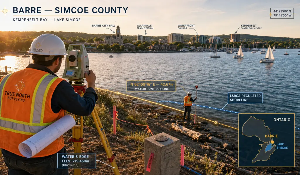
Regulatory awareness is a big part of working in Barrie. The Lake Simcoe Region Conservation Authority and the Nottawasaga Valley Conservation Authority both have jurisdiction across different parts of the city, and the rules near the Kempenfelt Bay waterfront, Hewitt's Creek, and the surrounding protected wetlands are taken seriously. If your project sits near any of those areas, getting the topographic data right early is what keeps your permits on track.
We work with homeowners, builders, lawyers, and developers across Barrie on everything from standard house surveys and boundary determinations to full construction layout for commercial and industrial projects in the south end. We know the local landscape — literally and from a regulatory standpoint — and we'll make sure your project has the survey foundation it needs to move forward without surprises.
Barrie's defining natural masterpiece is undeniably Lake Simcoe. Building magnificent waterfront properties or expanding infrastructure near these incredibly sensitive ecological zones strictly demands total compliance with highly stringent LSRCA regulations. We diligently execute highly detailed 3D topographic surveys to meticulously map critical floodplains, dramatic erosion hazard limits, and steep top-of-bank boundaries, providing the exact empirical data officially required to securely obtain specialized environmental building permits safely and exceptionally responsibly.
As the city actively expands its municipal borders to enthusiastically welcome new residents, massive residential subdivisions within the Salem and Hewitt's Secondary Plan areas are actively reshaping the community's southern footprint. We heavily partner with large-scale land developers to provide comprehensive construction layout services, ensuring that new road networks, vital deep utilities, and individual residential lots are mathematically established according to officially approved municipal draft plans.
The bustling Highway 400 corridor running directly through Barrie serves as the booming economic backbone of the region, seeing continuous commercial retail and industrial expansion. We flawlessly provide robust construction layout and incredibly precise Site Plan Control surveys for massive new manufacturing facilities, sprawling logistics warehouses, and busy retail centers, absolutely ensuring your commercial project perfectly aligns with rigorous municipal engineering standards.
In the charming, century-old heritage neighborhoods of downtown Barrie and historic Allandale, original survey monuments are frustratingly frequently lost or completely destroyed over the decades. We passionately conduct meticulous archival title research and utilize incredibly precise field measurements to definitively re-establish historic legal property boundaries. This incredibly vital professional service actively resolves tense neighborhood fenceline disputes and expertly prevents incredibly costly construction encroachments during modern architectural renovations.
For ambitious property owners looking to completely modernize or creatively rebuild on existing older residential lots, particularly those updating historic summer cottages into permanent luxury residences, we seamlessly provide the essential Surveyor’s Real Property Reports (SRPR) required by the local municipality. We accurately pinpoint existing lot lines, strict zoning setbacks, and hidden utility easements so your beautiful new architectural designs are approved effortlessly, keeping your construction schedule entirely intact.
As the rapidly growing city actively upgrades its critical municipal infrastructure and brilliantly expands its essential GO Transit corridors, we proudly partner with massive civil contractors to continuously deliver incredibly robust construction surveys. From expertly laying out incredibly complex underground sanitary sewer corridors to setting highly precise structural anchor bolts for completely new suburban overpasses, our highly advanced robotic instrumentation absolutely guarantees that critical municipal infrastructure is built safely.
Explore more information to help you navigate your property projects: