

Reference Plans (R-Plans) — Ontario Land Survey Documentation. If you've been dealing with a property transaction, a boundary issue, or a development approval in Ontario, there's a good chance someone has mentioned a Reference Plan. Here's what it actually is and why it matters.
A Reference Plan — commonly called an R-Plan — is an official plan of survey prepared by a licensed Ontario Land Surveyor and deposited at the local Land Registry Office. Once it's filed, it becomes a permanent public record. It gives everyone involved in a transaction — buyers, sellers, lawyers, lenders, and municipalities — a precise, legally recognized way to describe exactly what piece of land is being dealt with.
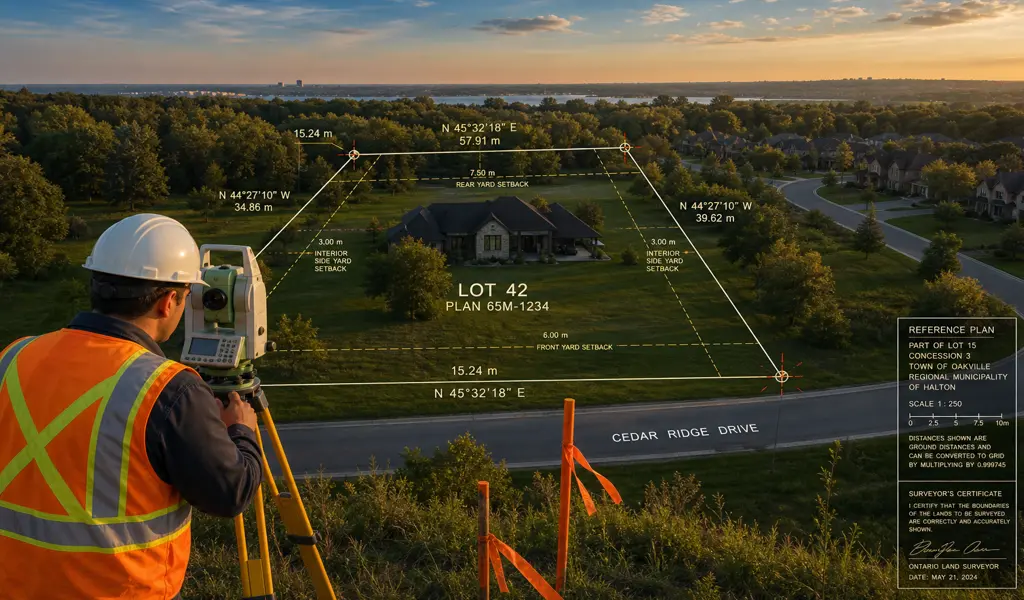
Think of it as the document that removes ambiguity. Instead of relying on vague metes-and-bounds descriptions buried in old deeds, an R-Plan gives a clear graphic representation of the parcel with exact dimensions and boundaries that anyone can reference.
A Reference Plan is not necessary for every single property transaction, but it becomes an absolute requirement in several specific scenarios where land boundaries are being created, altered, or formally defined.
If you own a large plot of land and wish to split it into two or more separate parcels, the local Committee of Adjustment will require a formal Reference Plan to officially define the exact dimensions of each newly created lot before any sale or development can take place.
Occasionally, a utility company needs the legal right to run infrastructure across your property, or a neighbor might require a documented right-of-way. A Reference Plan visually isolates and defines the exact physical area of this easement.
In older neighborhoods, historic property deeds might describe boundaries using outdated landmarks. When these properties are sold or targeted for major renovations, a Reference Plan is required to translate ambiguous descriptions into modern spatial data.
When a property is being transitioned from the older land registry system into the modern, digital Land Titles system, an R-Plan is frequently required to guarantee the absolute accuracy of the property lines moving forward.
Creating a Reference Plan is a meticulous process that blends deep historical research with advanced spatial technology. It is not an overnight task, as it requires a high degree of precision and strict legal authorization.
Before any equipment is set up on your property, a thorough investigation takes place. This involves digging into the archives to review historical deeds, previous surveys, and adjoining property records.
Using highly calibrated, state-of-the-art surveying equipment, precise measurements of the land, existing boundary markers, fences, and relevant structural foundations are taken to establish the facts on the ground.
The raw data gathered from the field is brought back into the drafting environment. Here, the physical measurements are rigorously compared against the legal deed descriptions to resolve any discrepancies and accurately draft the final, visual plan.
After the drafting is finalized and the plan is rigorously reviewed for accuracy, it is officially filed at the Land Registry Office. It is assigned a unique Reference Plan number.
It is crucial to understand that property law dictates only a fully licensed professional land surveyor has the legal authority to prepare, sign, and deposit a Reference Plan. This strict regulation ensures that the individuals defining your legal property boundaries have undergone rigorous academic training and adhere to the highest ethical and practical standards of the profession.
Whether you are embarking on a major commercial subdivision project or simply securing a minor variance for your family home, having a perfectly executed Reference Plan is the foundation of a smooth, legally sound process. It provides peace of mind, protects your financial investment, and ensures that your property rights are clearly defined and officially protected for generations to come.
Explore more information to help you navigate your property projects: