

Registered Plans of Subdivision — Land Surveying for Residential & Commercial Development. Turning raw land into a functioning community is one of the most complex things you can do in real estate development. It's also one of the most regulated.
When a developer, municipality, or investor group decides to divide a large parcel into new lots, blocks, or units for the first time, the entire process starts with one document: a Registered Plan of Subdivision.
At KAD Lanka Surveying, we've seen what happens when this foundational work isn't done right — and we've spent years making sure it is. A Plan of Subdivision isn't just lines on a drawing. It's the legal document that defines every lot boundary, assigns lot numbers and precise dimensions, and establishes the framework that everything else — permits, titles, mortgages, building starts — is built on top of.
Getting the plan right means thinking beyond the lot lines. A well-prepared subdivision plan accounts for the full picture of how a community actually functions:
Getting through the municipal planning process takes more than accurate measurements — you need a survey team that understands how the system works and what each approval stage actually requires.
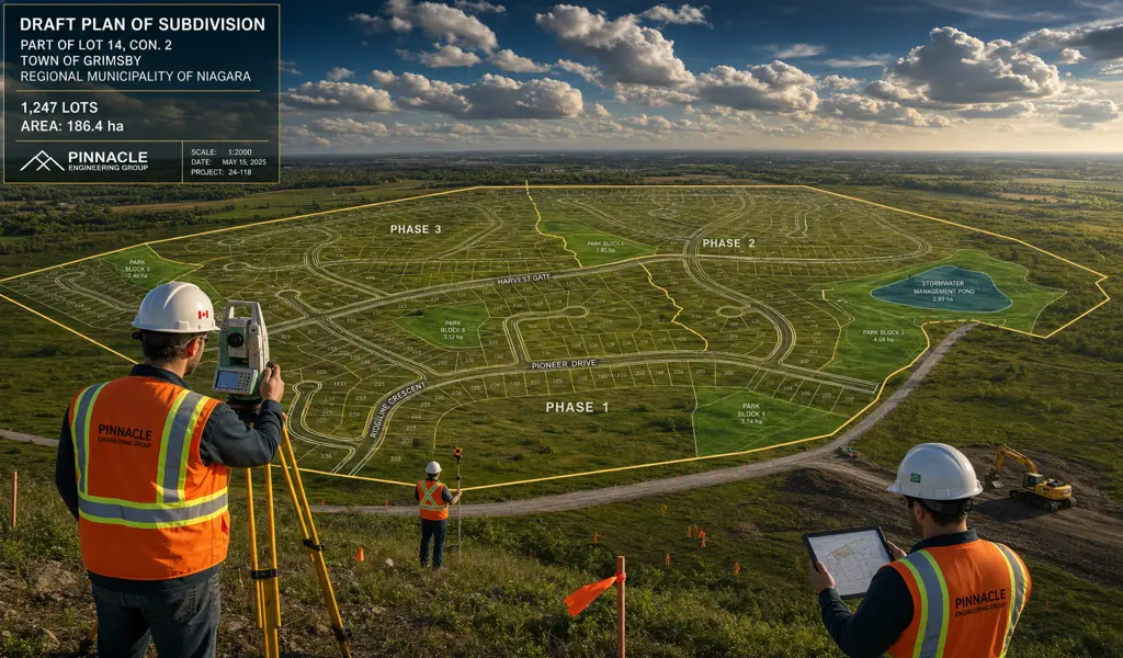
The journey typically begins with a Draft Plan of Subdivision. During this highly collaborative initial phase, our senior professional land surveyors work incredibly closely alongside urban planners, civil engineers, and specialized environmental consultants. We seamlessly integrate massive amounts of spatial data, effectively combining rigorous boundary surveys with incredibly detailed topographic mapping to completely ensure the proposed community layout beautifully aligns with the natural, pre-existing terrain and stringent density bylaws.
Once the local municipality officially grants Draft Plan Approval, the project immediately transitions into a highly rigorous phase of strict compliance and intense field execution. Our highly experienced surveying crews deploy directly to the physical site using the most advanced robotic total stations and high-precision GPS networks globally available. We meticulously plant heavy, highly durable iron survey monuments deep into the unyielding earth to permanently, indisputably mark the brand new property corners and intersecting street lines.
The final, triumphant step in this monumental journey is the official preparation and rigorous professional certification of the Final Plan of Subdivision. Our licensed Ontario Land Surveyors personally conduct an incredibly exhaustive internal quality control review, absolutely ensuring every single mapped angle, plotted distance, and bearing is statistically and mathematically flawless before it ever leaves our drafting desks.
Once the final plan is officially deposited and meticulously recorded at the local Land Registry Office, the original sprawling mother property is legally extinguished, and the hundreds of brand new individual lots officially come into legal existence. This monumental administrative action officially unlocks your massive real estate investment, finally allowing the newly minted parcels to be legally sold, transferred, and actively developed by eager homebuilders.
There's a human side to subdivision work that's easy to lose in the technical details. The lot lines we survey today become the property boundaries where families build their homes, where kids grow up playing in the park block down the street, and where a local business owner opens their doors for the first time. That context matters to us, and it shows in how carefully we do the work.
It also matters because the stakes are real. A boundary error on a subdivision plan doesn't just mean a correction — it can mean construction delays, title disputes with neighboring landowners, and municipal approvals that stall out while everyone figures out who's responsible. Those problems are expensive and entirely avoidable with the right survey team from the start.
When you bring KAD Lanka Surveying onto a subdivision project, you get a team that treats your development the same way we'd want someone to treat ours — with careful attention at every stage, clear communication when something needs your input, and survey work that holds up under scrutiny from the municipality, the conservation authority, and the land registry. From first field shots to final registered plan, we're with you the whole way.
Explore more information to help you navigate your property projects: