

Land Surveying in St. Catharines, Ontario — Serving the Niagara Region
St. Catharines sits in one of the most geographically interesting parts of Ontario. The Welland Canal runs right through the city, Lake Ontario borders it to the north, the Niagara Escarpment rises to the south, and Twelve Mile Creek winds through the middle of it all. That landscape is part of what makes the Garden City such an attractive place to live and invest — and it's also what makes accurate survey work here more involved than most.
The city's real estate market has picked up considerably in recent years as buyers and investors have moved into the Niagara region looking for value and quality of life. New residential development, commercial projects along the major corridors, and industrial activity near the canal are all driving demand for reliable, legally sound survey data.
The regulatory side here is real and worth understanding early. The Niagara Peninsula Conservation Authority has jurisdiction over a significant portion of the city — anything near Twelve Mile Creek, the Lake Ontario shoreline, or the Escarpment face needs proper topographic mapping before permits can move forward. Getting that work done right the first time saves you from the kind of delays that cost real money.
We work with homeowners, real estate lawyers, builders, and commercial developers across St. Catharines and the broader Niagara Region. From a standard house survey for a property transaction to full construction layout for a large industrial or commercial project near the canal corridor — we cover it all, and we know the local landscape well enough to keep your project moving.
Whether you are purchasing a stunning historic home in the beautiful community of Port Dalhousie or actively building a custom residential infill property near the downtown core, securing an accurate house survey is your very first line of legal defense. We provide the essential Surveyor’s Real Property Reports (SRPR) strictly required by local municipalities, accurately pinpointing existing property lines, strict zoning setbacks, and hidden utility easements so your architectural designs are approved effortlessly.
In the established, beautifully tree-lined neighborhoods of St. Catharines, original physical property markers are frequently buried, moved, or completely destroyed over the passing decades. A comprehensive lot survey is legally essential to definitively re-establish historic property boundaries. This vital professional service actively resolves tense neighborhood fenceline disputes and expertly prevents incredibly costly construction encroachments during modern architectural renovations or landscape upgrades.
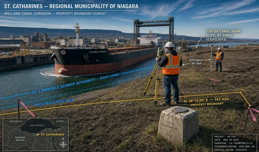
As the city actively expands its economic footprint alongside major transportation corridors, we proudly partner with large civil contractors to continuously deliver incredibly robust construction surveys. From laying out complex underground utility corridors to setting precise structural anchor bolts for new commercial warehousing facilities, our advanced robotic instrumentation guarantees that critical infrastructure is built safely and accurately to exact structural engineering specifications.
The natural waterways and deep, lush ravines of St. Catharines require absolute environmental respect. Building properties near these incredibly sensitive ecological zones demands total compliance with stringent NPCA regulations. We execute highly detailed 3D topographic surveys to meticulously map critical floodplains, erosion hazard limits, and top-of-bank boundaries, providing the exact empirical data required to secure specialized environmental building permits safely and responsibly.
Surrounding the immediate urban core of the city lies the expansive, highly productive agricultural landscape of the celebrated Niagara wine region. We passionately assist rural property owners and vineyard families in cleanly navigating the local Committee of Adjustment for land severances. We meticulously prepare precise severance sketches and deposit final Reference Plans to formally create legally registered, highly valuable rural parcels.
The exciting revitalization of downtown St. Catharines and the ongoing expansion of suburban retail centers strictly require highly comprehensive spatial documentation. We flawlessly produce detailed Site Plan Control surveys that meticulously map existing utilities, structural building footprints, and parking configurations, forming the absolutely essential blueprint required by the planning department for major mixed-use commercial intensification and exceptionally smart urban planning.
Explore more information to help you navigate your property projects: