OUR Surveying SERVICES

We have you covered.

Professional Property
Surveying Services

Serving Hamilton, Burlington, Oakville, Mississauga and Toronto

Property surveys, surveyor's real property report to site plans, at KAD Lanka Surveying Inc., we utilize state-of-the-art technology and advanced data processing systems to deliver highly accurate and reliable land surveying solutions across Ontario. With offices in Dundas and Tottenham, our licensed Ontario Land Surveyors proudly serve Hamilton, Burlington, Oakville, Mississauga and the Greater Toronto Area (GTA). Explore our comprehensive suite of services designed to meet the rigorous standards of your next project.

Reference Plans

These plans are deposited in the local land registry office and are required for land severance. They show the property boundaries, dimensions, and any features that may affect the title, such as easements, rights-of-way, fences, or retaining walls. All plans must be prepared by a licensed Ontario Land Surveyor.

Surveyor's Real Property Report

Prepared under Sections 28–30 of O. Reg. 216/10 of the Surveyors Act, this report shows the location of buildings and structures relative to property boundaries. It also identifies physical features and any easements, along with a written report outlining any issues.

Who needs it?
  • Owners/Buyers: Confirms boundaries, building locations, and identifies boundary issues.
  • Sellers: Provides buyers with accurate property size and extent information.

Land Severance & Plan of Survey

Refer to a reference plan or a surveyor’s real property report or any other survey plans. These plans are not deposited in the Land Registry Office. Most municipalities with an approved official plan have specific policies and requirements. A land severance is used for the separation of a piece of land to form a new lot or a new parcel.

Topographical Surveys

Used to identify and map horizontal and vertical locations of existing features (natural and manmade) on the property and slightly above or below the ground surface. Required for engineers and planners to design proposal developments.

We provide:
  1. Volume calculations
  2. Area calculations
  3. Digital terrain models
  4. Cross sections

Site / Grading Plan

A drawing or set of drawings that provides the location of existing and proposed improvements with contours and grade elevations of the land. The purpose of the grading plan is to provide a better drainage system from buildings for the benefit of property owners.

Horizontal & Vertical Control Surveys

Establishing horizontal and vertical controls to create a framework which can control the other surveys within the site and adjust accordingly. Horizontal controls provide position coordinates (Northing/Easting). Vertical controls determine elevation with respect to mean sea level. Accuracy varies depending on the type of survey.

Precision Surveying Monitoring

The purpose of a deformation survey is the determination of movements of a structure such as a building, retaining wall, bridge, or tunnel. If there is any movement, this survey expedites the implementation of protective engineering actions to avoid or minimize damages.

Plans of Subdivision

These plans subdivide property into two or more new parcels, units, or lots set out for the first time. They typically include surveyed boundaries, lot numbering, dimensions around lots, future consideration of streets (with names/widths), and blocks reserved for community and commercial buildings like schools, parks, and plazas.

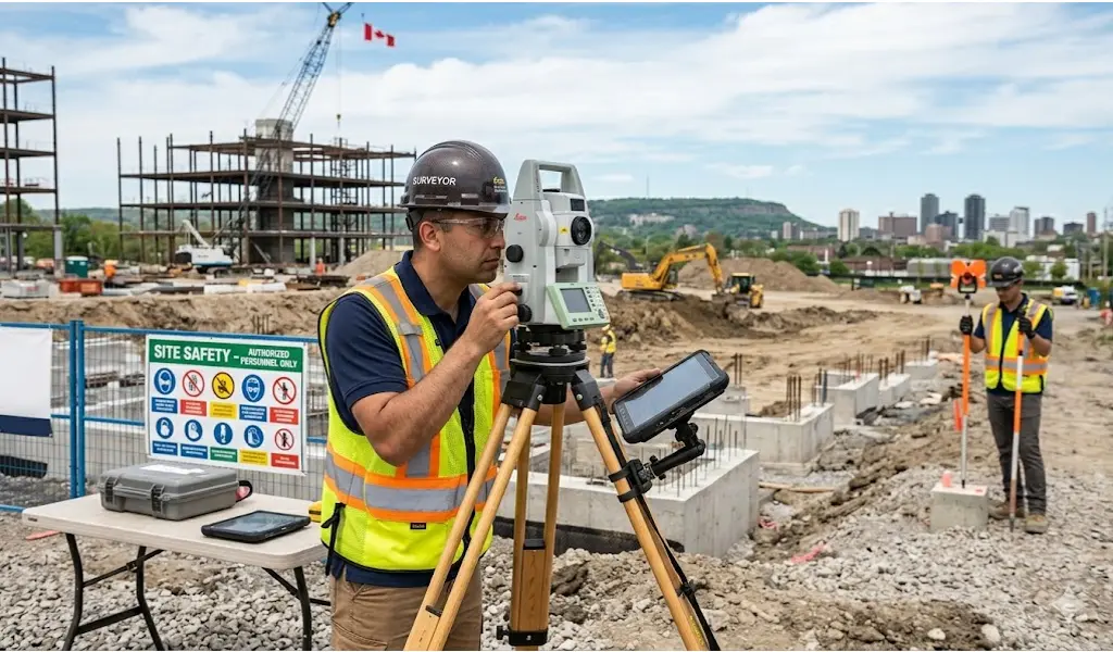
Construction Surveys

Providing critical layout and verification services for development sites, including:

  1. Building Layout
  2. Shoring Pile Layout
  3. Borehole Location Layouts
  4. Gridline Layouts
  5. As-Built Surveys

Frequently Asked Questions

Expert answers to common land surveying questions across Hamilton,  Scarborough, Markham and Toronto 

Whether you are building a commercial addition in Toronto or putting up a new residential fence in Mississauga, a professional land survey ensures you know your exact legal boundaries. Relying on visual estimates can lead to bylaw infractions, costly legal disputes, or even being forced to tear down completed work.
Yes! Fences are one of the leading causes of neighborly disputes. Having an Ontario Land Surveyor accurately stake your exact boundary line before you dig ensures your fence is placed entirely on your property, protecting your investment and maintaining peace with your neighbors.
While not strictly mandatory by law for every sale, it is highly recommended and often required by mortgage lenders and title insurance companies. A current Surveyor's Real Property Report (SRPR) protects you from inheriting hidden problems, such as a neighbor's garage sitting a foot over your new property line.
While an old survey can be a helpful visual reference, it only represents the property on the specific day it was drawn. If previous owners added a shed, widened a driveway, or if local municipal bylaws changed over the years, that old document is no longer legally reliable for new construction, permits, or property sales.
The cost varies significantly depending on the size, age, and complexity of your property. Surveying a sprawling commercial lot in Markham requires different time and resources than surveying a narrow, historic residential lot in downtown Toronto. We provide custom, transparent quotes based strictly on your project's specific needs.
Absolutely. Our technical teams are fully equipped with advanced GNSS technology and robotic total stations to handle complex, large-scale construction surveys, site grading plans, and precision monitoring for extensive commercial and industrial developments.
A Reference Plan maps the 2D legal boundaries of a property and is deposited in the Land Registry Office (often for land severances). A Topographical Survey adds the 3D element—mapping the physical features, elevations, contours, and grading of the land. Engineers and architects rely heavily on topographical surveys to design new builds.
Boundary disputes are stressful, but they are best resolved with concrete facts. Our licensed surveyors can conduct a precise boundary check to locate the true, legal lot lines. We provide the legally binding documentation required to settle encroachments confidently and amicably.
Those are Standard Iron Bars (SIBs), which act as official legal boundary monuments. It is illegal to remove, move, or destroy a surveyor's monument under the Ontario Surveys Act. If you find one on your property, please leave it exactly where it is!
Timelines depend entirely on the scope of the project and the availability of municipal land registry records. A straightforward residential boundary stakeout might take a week or two, while a complex commercial subdivision plan will take longer. We pride ourselves on efficiency and will provide a clear timeline along with your quote.
Generally, no. As long as our field crews have clear, unobstructed access to the exterior of your property (such as unlocked gates), you do not need to be present while we conduct the outdoor fieldwork.
Getting started is simple! Contact our Dundas or Tottenham offices with your property address and a brief description of what you are trying to achieve (e.g., building a fence, severing a lot, or beginning a commercial development). We will review the necessary records and provide a customized estimate.

Ready to Get Started?

Contact us today to discuss your project requirements and request a customized quote. Let us map accuracy into your next project.

GET A QUOTE
Call Now: (647) 267-4322