
Purchasing, developing, or managing real estate in Hamilton or the Greater Toronto region is one of the most significant financial investments you will ever undertake. To protect that investment effectively, having a precise, clear, and legally binding understanding of your property’s physical boundaries is absolutely critical. This is precisely where a Surveyor’s Real Property Report (SRPR) becomes an indispensable, highly valuable tool for property owners, buyers, and legal professionals alike.
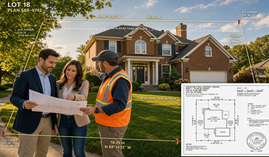
A Surveyor's Real Property Report is a comprehensive legal document and a meticulously detailed plan of survey that is prepared exclusively by a licensed professional land surveyor. It clearly and accurately illustrates the exact location of your legal property boundaries and maps out all permanent structures, physical improvements, and relevant features in direct relation to those legal lines. Unlike a basic municipal sketch, a rough architectural rendering, or an outdated historical deed, an SRPR provides an authoritative, up-to-date, and legally verified snapshot of the precise land area you truly own. This level of detail guarantees absolute clarity, facilitates smoother property transactions, and serves as the ultimate safeguard against costly legal disputes with neighbors or municipalities.
While you might assume that the physical fences and hedges define your property lines, this is rarely the legal reality. A Surveyor's Real Property Report is critical in several high-stakes scenarios where knowing the exact legal boundaries is mandatory for moving forward with confidence.
When buying or selling a home, an SRPR provides the buyer, the real estate agent, and the financial lending institution with absolute certainty regarding what is actually being purchased. It immediately highlights any problematic encroachments, such as a neighbor's garage spilling over the property line, preventing future lawsuits and protecting title insurance policies.
If you are planning to build a home addition, construct a detached garage, or install an in-ground swimming pool, municipal building departments strictly require an SRPR. This document proves that your proposed construction adheres to all required local zoning bylaws and mandatory building setback limits.
Building a new fence based on guesswork is a recipe for disaster. An SRPR allows you to safely place boundary markers, ensuring your new expensive fencing or retaining wall is built entirely on your own land, thereby avoiding the staggering cost of tearing down structures that accidentally crossed into the neighboring lots.
Disagreements with neighbors over the exact location of property lines are stressful and common. An up-to-date Surveyor's Real Property Report is the definitive legal authority in these conflicts, providing objective, unarguable facts that resolve disputes effectively and restore peace of mind.
An SRPR is typically composed of two highly detailed components: the Plan of Survey and the Written Report. The visual plan provides a to-scale diagram showing the precise dimensions of the lot, the location of primary buildings, fences, driveways, retaining walls, and any registered utility easements that cross the property. The accompanying written report contains the professional surveyor's documented findings. It will explicitly note any compliance issues with local municipal zoning bylaws, highlight any discovered encroachments, and detail any registered deed restrictions or existing title complications that the owner needs to be aware of.
Generating a trustworthy Surveyor's Real Property Report is a rigorous process that demands specialized education and advanced technology. Our dedicated team of professionals approaches every single project with a comprehensive methodology to ensure absolute accuracy.
Before we step foot on your property, our experts conduct deep historical research at the local Land Registry Office. We pull current and historical deeds, analyze underlying registered plans, and review documentation for adjacent properties to build a complete legal picture of the site.
Our highly trained staff come to your location using advanced, highly calibrated instruments such as robotic total stations and high-precision GPS. We diligently search for original iron boundary bars, take exact measurements of all existing structures, and establish the factual layout of the land.
The robust field data is brought back to our office where spatial analysts and CAD team calculate the findings. We rigorously compare our modern physical measurements against the historical legal deed descriptions to pinpoint your exact boundaries with mathematical certainty.
The final phase is a stringent quality control review. A fully licensed professional surveyor closely examines all calculations, plans, and reports. Once satisfied that it meets all regulatory standards, the surveyor signs and seals the document, granting it full legal authority.
At KAD Lanka Surveying, we understand that an accurate SRPR is more than just a piece of paper; it is the foundation of your property rights. By choosing our experienced professionals, you guarantee that your project begins with a flawless, legally sound understanding of your land, enabling you to build, sell, or manage your real estate with absolute confidence and piece of mind.
Explore more information to help you navigate your property projects: