

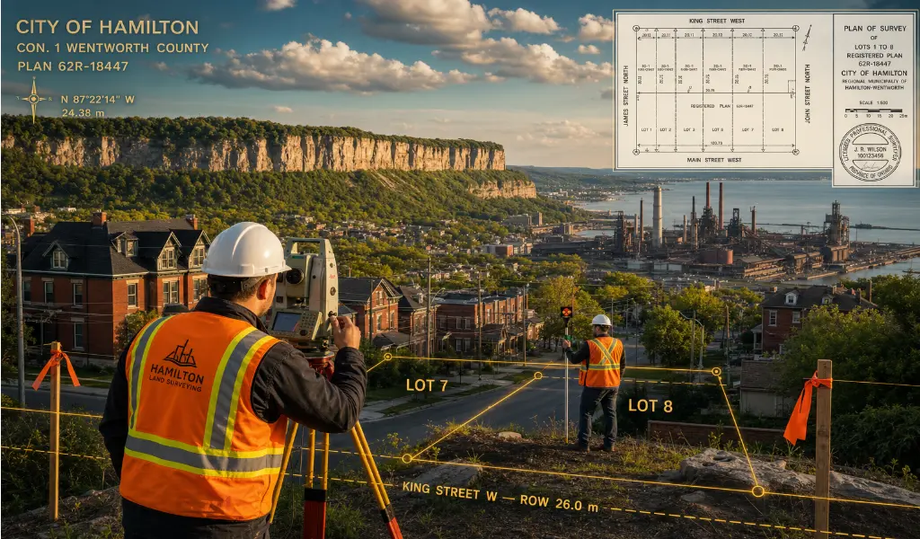
Land Surveying in Hamilton, Ontario. From the Lower City to the Escarpment.
Hamilton has changed a lot over the past decade, and development pressure across the city reflects that. The lower city core is seeing significant residential intensification and heritage infill. The Mountain continues to grow outward. Ancaster, Flamborough, and Glanbrook are attracting rural estate and agricultural severance work. And through all of it, the Niagara Escarpment runs right across the middle of the city, dividing the landscape — and the regulatory picture — in two.
That geography matters when it comes to survey work. The Hamilton Conservation Authority and the Niagara Escarpment Commission both have meaningful jurisdiction over large portions of the city, and the requirements vary significantly depending on exactly where your project sits. A boundary job in Westdale looks nothing like a topographic survey on a Glanbrook rural parcel, and a construction layout near the escarpment face comes with a different checklist than work at the airport logistics corridor near the International Airport.
We work across all of it — residential infill in Dundas and Westdale, estate surveys in Ancaster, commercial and industrial projects in the lower city, and rural severances out in Flamborough. Our crews know the local terrain and the local rules well enough to give you accurate data without the back-and-forth that slows projects down.
If you're working in Hamilton and need a surveyor, call us today for a no obligation quote.
Building on or near the "Mountain" involves navigating steep grades, complex drainage, and strict NEC regulations. We execute highly detailed 3D topographic surveys that accurately capture elevation changes, retaining walls, and natural bedrock features, providing engineers with the critical data needed for safe, compliant foundation and grading designs.
Hamilton’s industrial sector and waterfront port remain vital economic engines. We deliver robust construction layout services for massive warehouse expansions, manufacturing facilities, and heavy infrastructure upgrades, ensuring structural elements, anchor bolts, and utility corridors align perfectly with demanding engineering tolerances.
In century-old neighborhoods like Durand, Corktown, and Stinson, historical property descriptions can be ambiguous, and original survey monuments are often long gone. We conduct meticulous archival title research and precise field measurements to re-establish legal boundaries, resolving historical discrepancies and preventing encroachment disputes during modern renovations.
For landowners in Hamilton's sprawling rural communities—such as Glanbrook, Binbrook, and Flamborough—we provide expert land severance services. We prepare the necessary reference plans and severance sketches required by the local Committee of Adjustment for farm splits, estate planning, and rural lot additions.
As Hamilton focuses on increasing housing density along future transit corridors, precise boundary and site plan control surveys are essential for "missing middle" developments. We ensure that townhomes and mid-rise residential projects fit mathematically within tight urban lots while strictly respecting municipal setback bylaws.
Hamilton is famous for its waterfalls, creeks, and deep ravines. Development near these sensitive ecological zones requires strict compliance with the HCA. We survey and map top-of-bank limits, floodplains, and environmental buffers to support your specialized building permit applications effectively.
Developing commercial retail spaces or suburban business parks requires comprehensive spatial documentation. We produce detailed site plan control surveys that plot existing utilities, landscaping, building footprints, and parking configurations, forming the essential blueprint required by the City of Hamilton’s planning department for final project approval.
Hamilton is a city of two very different landscapes, and anyone who's worked here knows it. The lower city sits on flat clay soils with its own drainage and foundation considerations, while the Mountain is a different story entirely — rocky terrain, steep grades, and escarpment-related setbacks that change the survey scope on almost every project.
Knowing Hamilton's zoning bylaws, understanding how the conservation authority's jurisdiction plays out across different parts of the city, and anticipating where projects typically run into friction — that's what keeps your job moving.
If you're developing in Hamilton, give us a call today!
Explore more information to help you navigate your property projects: