

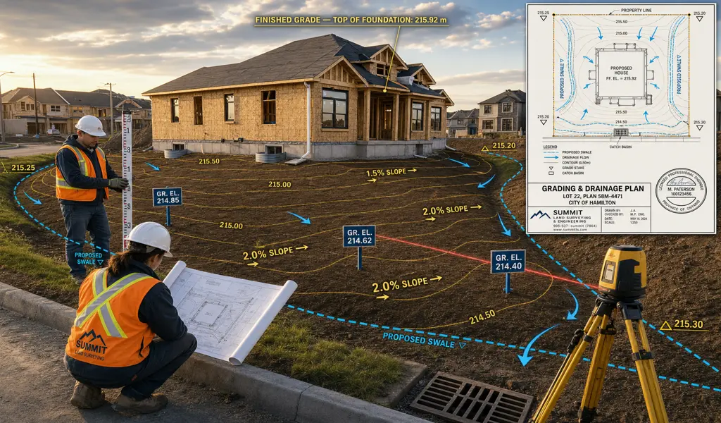
Site & Grading Plans — Engineered Drainage Solutions for Residential & Commercial Projects. Before a building permit gets issued for new construction, a home addition, or significant landscaping work, your municipality needs to see one thing: proof that water will drain the way it's supposed to. That's what a Site and Grading Plan is for. It's an engineered drawing that maps out exactly how the land will be shaped — ground slopes, finished elevations, and the placement of new structures — so that surface water moves away from buildings and toward the right places. Municipal building departments require it because poorly managed drainage causes real problems, and those problems don't stay on one property.
Bad grading is one of the most common and expensive mistakes in residential construction. Water that pools against a foundation or drains toward a neighbour's lot leads to basement flooding, foundation damage, and neighbour disputes that can get legal very quickly. A properly prepared grading plan gives your earthwork contractor a clear, accurate roadmap so none of that happens.
Building departments will simply not issue construction permits without an officially approved grading plan. This professional document empirically proves to the city that your proposed project adheres perfectly to their specific lot grading criteria and regional stormwater management policies.
The primary functional goal of proper grading is to aggressively channel water away from your building’s foundation. Precise sloping permanently prevents water from dangerously pooling against the concrete, drastically reducing the serious risk of hydrostatic pressure, basement leaks, and long-term structural decay.
Altering the natural elevation of your land can easily and inadvertently redirect heavy rainwater directly onto an adjacent property. A certified grading plan explicitly ensures that your new development safely manages its own surface water runoff entirely, preventing costly legal battles with frustrated neighbors.
A comprehensive site plan does not simply manage dirt; it coordinates the exact spatial placement of essential hardscaping features. It accurately map out required retaining walls, catch basins, driveways, and concrete culverts, ensuring all elements function harmoniously within the newly engineered landscape.
Creating an exceptionally effective, fully compliant plan involves a rigorous, multi-step methodology.
It begins by capturing a highly detailed 3D topographic survey of the existing land, confidently establishing a precise baseline of current ground elevations, existing structures, and natural features.
Using the raw topographic field data, a specialized design team carefully overlays your proposed architectural footprint. Then it is mathematically calculated for the required slopes, specifying exact cut and fill volumes to ensure surface water flows efficiently away from the new structure.
The finalized, highly detailed CAD drawings are then submitted directly to the local building department or conservation authority.
Once your chosen contractor completely finishes the physical earthwork, There will be a return to the site. Where a comprehensive final survey to formally certify that the physical grading absolutely matches the approved design, seamlessly insuring your final municipal approval.
With KAD Lanka Surveying, you absolutely guarantee that your project begins on a remarkably solid, expertly planned foundation. We take the guesswork out of complex water management strategies, providing the necessary technical expertise to keep your development completely dry, perfectly compliant, and legally protected.
Explore more information to help you navigate your property projects: