
Dividing a single parcel of land into multiple independent properties—a process legally known as a land severance or obtaining "consent to sever"—is one of the most effective strategies for property owners, investors, and developers aiming to maximize the financial value and functional utility of their real estate assets. However, creating new legal lots is a highly regulated municipal procedure governed by the Planning Act. To successfully navigate this complex legal landscape and secure the necessary approvals from your local Committee of Adjustment, an expertly drafted Plan of Survey is absolutely indispensable.
At KAD Lanka Surveying, we specialize in transforming your development vision into an approved reality. We provide the vital spatial data, precise boundary mapping, and legal documentation required to satisfy strict municipal conditions. Whether you are dealing with the dense urban zoning constraints of Toronto, navigating the rapidly expanding suburban subdivisions of Vaughan and Oakville, managing sprawling agricultural and rural acreages in Simcoe and Bradford, or supporting ongoing municipal growth in dynamic cities like London and St Catherine's, our comprehensive surveying services ensure your severance application proceeds smoothly, legally, and without unnecessary delays.
Property owners pursue a consent to sever for a variety of strategic, financial, and practical reasons. The municipal approval process dictates that each of these scenarios requires a highly accurate Plan of Survey to clearly define the new geometric limits of the land in question.
The most common reason for a severance is to divide a large, underutilized residential or commercial property into two or more separate, buildable lots. This process allows owners to sell the newly severed parcels for a substantial profit or develop them independently, significantly increasing the overall density and value of the original holding.
Sometimes, you do not want to create an entirely new lot, but rather adjust an existing boundary. A lot addition (or boundary adjustment) involves severing a small portion of land from one property and legally merging it with the abutting property. This is frequently used to resolve longstanding encroachment issues, enlarge a driveway, or improve backyard utility.
For families owning expansive rural or agricultural lands, a land severance is a crucial tool for estate planning. It allows parents to sever a dedicated portion of their farm or estate to gift or sell to their children, enabling the next generation to build their own homes while keeping the core property within the family.
A severance is not only for dividing land ownership. It is also the legal mechanism used to grant formal rights over a property without transferring the title. Whether it is providing a shared access driveway (right-of-way) for a landlocked neighbor or granting a permanent utility easement for municipal infrastructure, a survey plan is strictly required.
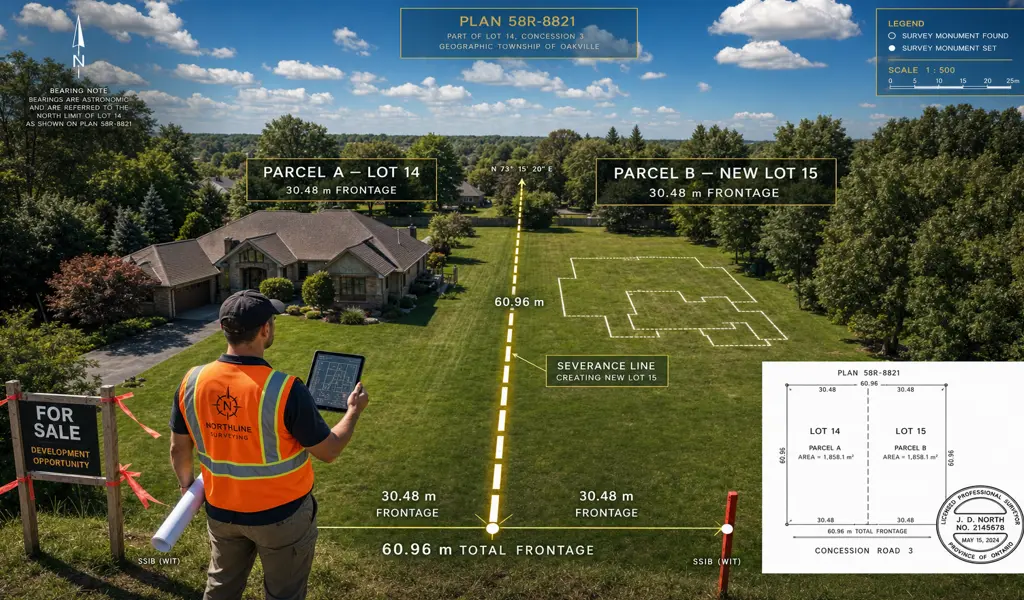
When you submit an application to the your city's Committee of Adjustment for a land severance, the municipality will not simply take your word on the proposed dimensions. They require an initial Severance Sketch—prepared by an Ontario Land Surveyor—that overlays your proposed new boundaries onto the existing topography. This sketch must detail lot areas, frontages, existing building setbacks, and driveways to prove that the proposed new lots comply with local zoning by-laws and official plans.
Once the Committee grants conditional approval for the severance, you are typically given a strict deadline (often one to two years) to fulfill all municipal conditions. The most critical condition is the submission of a final, finalized Reference Plan (R-Plan). This official Plan of Survey is deposited at the Land Registry Office, legally creating the new boundary lines on the public record so that the new deeds can be formally registered and transferred.
We guide property owners, real estate lawyers, and urban planners through every surveying phase of the severance process with precision and dedicated support.
We begin by conducting thorough research into the subject property's title, historic deeds, and current municipal zoning requirements. We help determine if your proposed severance is physically and legally feasible before you start the formal application process.
Our crews perform an initial field survey to locate existing boundaries and structures. We then draft a highly accurate preliminary Severance Sketch. This document forms the visual cornerstone of your application to the municipal Committee of Adjustment, demonstrating zoning compliance.
Following conditional approval by the municipality, we will return to the site. We physically plant specialized iron survey bars into the ground to permanently mark the newly created boundary lines, corners, and intersecting points for all future owners to reference.
The final step is the creation of the formal Reference Plan. Our licensed Ontario Land Surveyors meticulously draft, review, and sign the plan before officially filing it at the local Land Registry Office, thereby satisfying the legal requirements for your new deeds to be registered.
Navigating a land severance requires professionals that understand both the intricate mathematics of boundary surveying and the bureaucratic nuances of municipal planning. At KAD Lanka Surveying, our extensive experience across Southern and Eastern Ontario—from the bustling streets of Toronto and Vaughan to the developing corridors of Oakville, Bradford, and Simcoe, all the way to St. Catherine's and London—ensures your severance project is handled with unmatched professionalism, reducing your stress and protecting your financial investment.
Explore more information to help you navigate your property projects: