
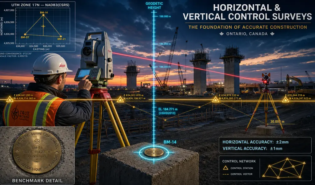
Behind every flawlessly executed highway interchange, soaring high-rise condominium, and sprawling industrial complex lies an invisible but absolutely essential framework of mathematical truth. This framework is formally known as a horizontal and vertical control network. In the highly demanding world of modern civil engineering, heavy infrastructure, and large-scale land development, estimating dimensions is simply not permitted. A Horizontal and Vertical Control Survey establishes an incredibly accurate, highly robust grid of physical reference points across a vast project site, ensuring that every subsequent measurement, complex architectural layout, and structural pour aligns perfectly with the overarching master spatial coordinate system.
At KAD Lanka Surveying, we fully understand that the ultimate success of your entire construction project fundamentally rests upon the absolute, unquestionable reliability of these primary control points. Horizontal control definitively establishes the precise X and Y coordinates (easting and northing), dictating exact property boundaries and structural alignments on a flat two-dimensional plane. Conversely, vertical control establishes the incredibly precise Z coordinate (elevation), strictly tying your site to a recognized national geodetic datum. Together, they form an unbreakable, three-dimensional spatial foundation. Whether you are tunneling deep underground for new municipal transit infrastructure, or erecting a sixty-story commercial skyscraper in the crowded urban core, our expertly established control networks guarantee absolute, unshakeable accuracy from the moment we first break ground until the final ribbon is triumphantly cut.
A standard boundary survey might easily suffice for constructing a simple backyard fence, but massive capital projects operate on entirely different scales of financial risk and structural complexity. Establishing a primary control network is legally and structurally mandatory for several critical, uncompromising reasons.
When engineers build a massive bridge or bore a deep transit tunnel from two completely opposite ends, they absolutely must meet perfectly in the exact middle. High-order control surveys eliminate the terrifying risk of structural spatial drift, ensuring heavy roads, steel rails, and underground pipelines connect seamlessly across miles of incredibly varied terrain.
Constructing a towering skyscraper requires continuously managing tiny margins of error. A specialized vertical control network allows structural engineers and formwork contractors to effectively transfer elevations upward, powerfully ensuring each newly poured concrete floor remains perfectly level and the central elevator cores stay flawlessly, remarkably plumb.
Modern volumetric mapping relies heavily on autonomous drones and complex LiDAR technology. However, to translate those beautiful aerial pixels into highly accurate, legally binding engineering data, we must establish physical Ground Control Points (GCPs). These heavily targeted control monuments lock the airborne data directly to the undeniable physical earth brilliantly.
For incredibly sensitive structures like hydroelectric dams, aging retaining walls, or exceptionally deep foundation excavations, ongoing safety is paramount. A permanent, highly stable control network situated safely outside the active zone of influence allows us to accurately measure microscopic structural shifting or dangerous ground subsidence over decades.
Establishing a zero-tolerance control network is an incredibly demanding scientific endeavor that seamlessly blends highly advanced geodesy with remarkably rugged fieldwork procedures.
Before deploying any equipment, our land surveyors meticulously design the geometric network. We strategically select incredibly stable, intervisible locations for the control monuments, purposely avoiding active areas prone to seasonal frost heave, extremely heavy construction traffic, or unavoidable future deep excavation.
We physically install highly durable survey monuments deep into the unyielding earth. Depending entirely on the specific project requirements, this might involve forcefully driving deep iron rods to refusal, drilling specialized rock posts securely into solid bedrock, or pouring heavy concrete pillars to guarantee absolute long-term stability.
Our field crews actively utilize the most advanced measurement technology globally available. We seamlessly employ dual-frequency Static GPS receivers, highly precise digital levels capturing sub-millimeter elevation changes, and sophisticated robotic total stations to tightly measure the intricate angles and distances between every single placed monument.
The raw data is brought back to our office, where our geomatics experts run extremely complex mathematical algorithms formally known as Least Squares Adjustments. This rigorous statistical process aggressively analyzes redundant field measurements, effectively isolating, strategically distributing, and practically eliminating microscopic observational errors to totally certify the network's ultimate, spectacular accuracy.
When millions of dollars and critical public safety are actively on the line, you absolutely cannot afford to build on unverified, loose assumptions. By confidently and proactively partnering with KAD Lanka Surveying for your specialized horizontal and vertical control needs, you invest in the ultimate peace of mind. We proudly deliver the indisputable spatial certainty required to eliminate incredibly costly mid-construction redesigns, and enthusiastically drive your most ambitious real estate developments forward. Call KAD Lanka Surveying Today!
Explore more information to help you navigate your property projects: