

Before a single shovel penetrates the soil for any construction, infrastructure enhancement, or land development project, having an exhaustive understanding of the existing terrain is absolutely paramount. The natural and artificial variations of a landscape dictate how water flows, where foundations can be safely poured, and how architectural designs must be adapted to fit the physical reality of the site. A Topographic Survey provides this vital foundational intelligence by precisely mapping the three-dimensional characteristics of a given parcel of land onto a highly detailed, two-dimensional plan.
At KAD Lanka Surveying, we deploy advanced spatial data collection techniques to meticulously document elevations, contours, and physical features. We routinely execute these highly technical surveys across a diverse range of Southern and Eastern Ontario environments. Whether you are navigating the intricate, varied elevations of the Niagara Escarpment in Hamilton, planning a sprawling commercial development in Scarborough, laying out a residential subdivision in Bradford or Newmarket, or managing complex grading requirements in rapidly growing municipalities like Whitby, Richmond Hill, Brampton, and Barrie, our topographic data serves as the indispensable blueprint for your project's engineers and architects.
A standard boundary survey shows you where your property ends, but it tells you nothing about the characteristics of the land itself. Topographic surveys are an essential prerequisite for design and development for several non-negotiable reasons.
Architects and structural engineers cannot design safely or efficiently in a vacuum. They require an exact mathematical representation of the ground's slopes and existing structures to design foundations, retaining walls, and building footprints that harmonize with the natural landscape rather than fighting against it.
Understanding water runoff is critical for any development. Topographic surveys identify high and low points, enabling civil engineers to design effective grading plans, storm sewers, and catch basins. This prevents disastrous on-site flooding and ensures your project complies with strict municipal stormwater regulations.
Knowing exactly where existing above-ground and visible below-ground utility markers reside is necessary for planning new connections. We map the locations of fire hydrants, manholes, hydro poles, and catch basins so your development can seamlessly integrate into the existing municipal infrastructure grid.
Local conservation authorities and building departments demand precise topographic data before issuing permits. Identifying significant environmental features—such as the exact location of mature trees, watercourses, or steep ravines—is often legally mandated to ensure responsible and approved land development.
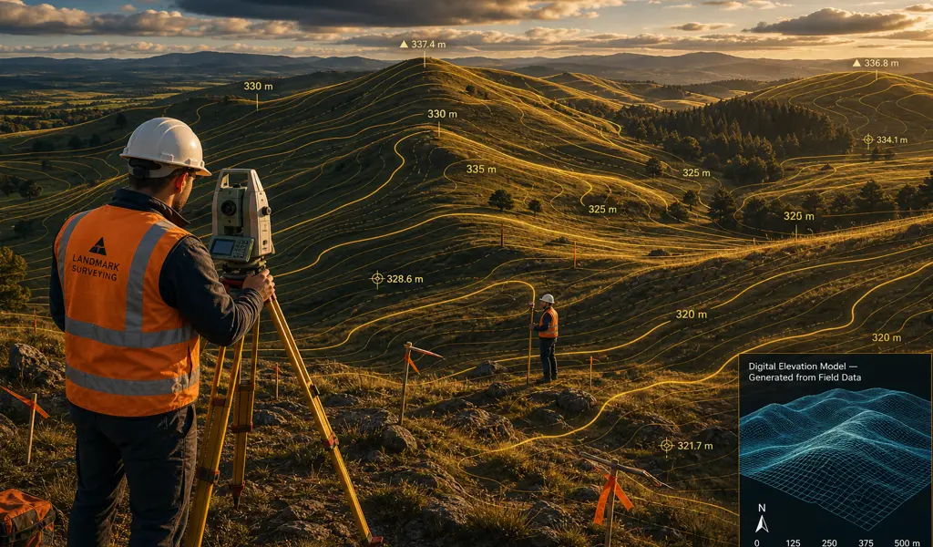
The level of detail in a topographic survey is tailored specifically to the needs of the client and their consulting engineers. Generally, the survey captures a comprehensive array of both natural and human-made features. Natural features include ground elevations, contour lines, embankments, bodies of water, and individual large trees or tree lines. Artificial features meticulously recorded include existing buildings, roadways, curbs, sidewalks, driveways, retaining walls, fences, and visible surface utilities. Every element is captured with pinpoint spatial accuracy to reflect the exact state of the site at the time of the survey.
Executing a reliable topographic plan requires a seamless integration of rugged fieldwork and sophisticated digital processing. Our team follows a rigorous internal protocol to ensure the data we deliver is flawless.
We begin by consulting directly with the client and their developer or design team to understand the specific requirements of the project. A custom survey limits parameters and specifies the exact level of detail required, ensuring an efficient and highly targeted data collection phase.
Our trained professionals bring advanced equipment to the site using a combination of industry-leading technologies. Depending on the terrain and scale, we utilize robotic total stations, Real-Time Kinematic (RTK) GPS rovers to capture thousands of distinct elevation points across the property.
The raw data points are uploaded into our advanced Computer-Aided Design (CAD) software. We process this data, connecting the points to generate continuous contour lines and accurate 3D surface models, translating field measurements into a highly readable digital map.
After a thorough quality assurance review by a licensed professional, the final deliverables are prepared. We provide fully layered DWG CAD files and high-resolution PDFs directly to the project architects and engineers, giving them the exact data foundation they need to commence design.
By partnering with KAD Lanka Surveying for your topographic mapping needs, you are investing in accuracy, efficiency, and profound expertise. Whether breaking ground in the busy urban core of Brampton, or managing varied topography in Whitby or Richmond Hill, our detailed surveys empower your team to design smarter, manage costs effectively, and move your development vision forward with absolute confidence.
Explore more information to help you navigate your property projects: