Monitoring Surveys & Structural Deformation Monitoring — Construction & Infrastructure Surveying
When heavy construction starts — a transit tunnel being bored, a deep excavation for a high-rise foundation, or a major infrastructure project in a dense urban area — the ground around it reacts. Structures settle. Walls shift. Neighboring buildings move in ways that are invisible to the eye but measurable with the right equipment. That's what monitoring surveys are for.
Deformation monitoring is the practice of tracking structural and ground movement over time using precision survey instrumentation. It's a specialized discipline, and when it's done right, it gives engineers, project managers, and owners the data they need to make informed decisions before small movements become serious problems.
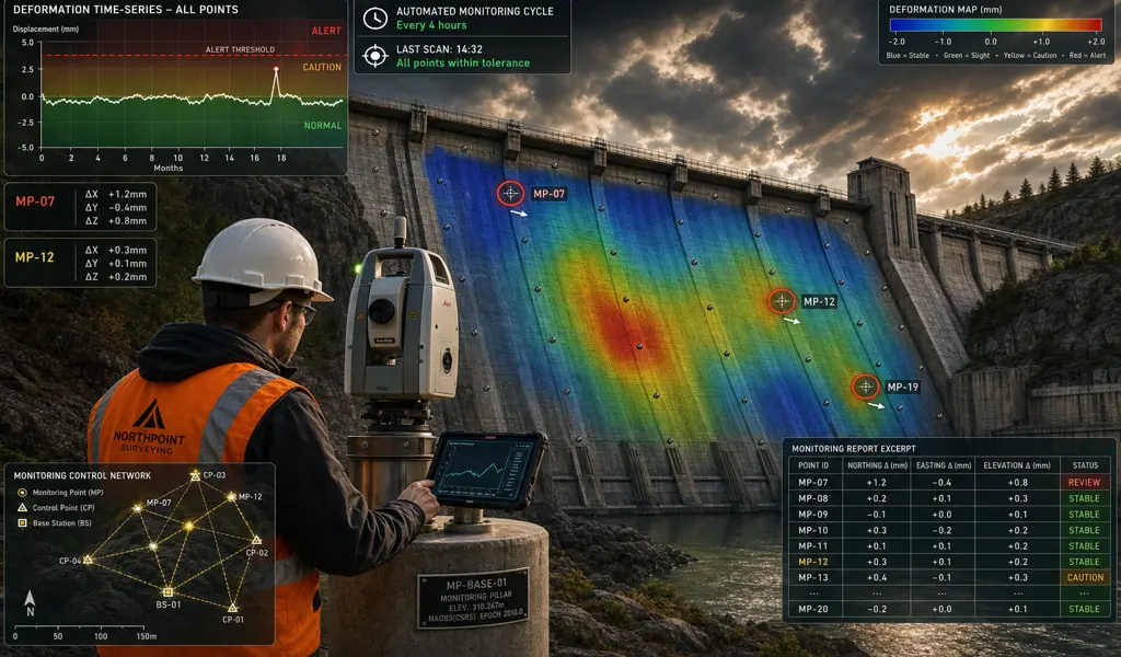
We use high-precision total stations, precise levelling equipment, and spatial monitoring networks capable of detecting sub-millimeter movement. The readings are systematic and ongoing — not a one-time snapshot, but a continuous record that shows exactly how a structure or the ground around it is behaving throughout the life of a project.
Catching a developing problem early — a slight increase in settlement rate, a wall beginning to deflect beyond tolerance — gives the engineering team time to respond. Missing it doesn't. That's the practical value of a well-run monitoring program, and it's why structural engineers and project owners specify it on projects where the consequences of getting it wrong are significant.
When you actively dig incredibly deep right next to existing buildings, the surrounding soil naturally and aggressively wants to shift. We strategically monitor massive steel tie-backs, concrete retaining walls, and adjacent structural foundations to ensure the intense excavation process does not inadvertently compromise the structural integrity of neighboring real estate assets.
Century-old buildings are notoriously sensitive to intense, repetitive ground vibrations commonly caused by nearby heavy construction, tunneling, or transit operations. We utilize highly specialized, totally non-invasive optical prisms to continuously monitor these delicate architectural treasures, ensuring they remain perfectly intact and completely undisturbed throughout your long development cycle.
Highway bridges, elevated rail lines, massive retaining walls, and commercial overpasses undergo immense dynamic loading and natural environmental degradation over their lifespans. Our long-term monitoring programs meticulously track dangerous physical fatigue, unexpected settlement, and thermal expansion, strictly providing structural engineers with the precise data needed to execute proactive, life-saving maintenance.
Natural forces can easily be just as immensely destructive as heavy construction. We continuously monitor incredibly sensitive geological areas prone to dangerous landslides, sudden sinkholes, or slow, steady soil consolidation. This highly specialized spatial tracking is absolutely vital for safely maintaining critical public infrastructure securely built upon unpredictable, highly volatile geographical fault lines.
Executing a flawless monitoring campaign is a highly demanding scientific endeavor that seamlessly blends advanced surveying geodesy with remarkable technological automation.
Before a single heavy shovel violently hits the dirt, we meticulously establish an unshakeable control network safely located well outside the active zone of influence. We actively take initial "zero-readings" of the target structures, creating a definitive, mathematically perfect baseline against which all future microscopic movements will be vigorously compared.
Depending entirely on the exceptionally unique environmental constraints of your specific project, our specialized field crew carefully install highly durable reflective optical prisms, precise electronic tiltmeters, or digital crack gauges directly onto the critical load-bearing structures being closely monitored.
For incredibly high-risk construction projects, we permanently deploy highly advanced automated robotic total stations that autonomously scan the target prisms incredibly frequently, operating 24 hours a day, 7 days a week. For longer-term, somewhat lower-risk engineering projects, our dedicated field crews conduct manual, highly precise observation epochs at strict daily, weekly, or monthly intervals.
The incredibly complex raw spatial data is instantly transmitted directly to our highly advanced software systems. If any tracked physical movement brutally exceeds the strict, pre-determined engineering safety tolerances, automated alarm notifications are immediately dispatched to your active site superintendents, allowing for exceptionally swift, decisive corrective action to effectively prevent disasters immediately.
Trusting the ongoing safety of your massive construction site to basic, rudimentary visual inspections is a wildly dangerous liability. At KAD Lanka Surveying, we bring a dedicated human touch to this highly technical scientific field. We personally understand the massive stress, the incredibly tight budgets, and the terrifying legal liabilities vividly associated with modern urban development projects. By proactively partnering with our dedicated team of monitoring professionals, you absolutely guarantee that your project remains safely within all strict engineering tolerances. We enthusiastically deliver the undeniable physical proof legally required to shield your development from completely unwarranted litigation, actively protect the surrounding vulnerable community, and keep your project confidently moving forward securely.
Explore more information to help you navigate your property projects: